

George Williams
Kerala Holidays - Kanyakumari
Kanyakumari is a town in the state of Tamil Nadu in India. It was also referred to as Cape Comorinearlier. Located at the southernmost tip of India, it is the geographical end of the mainland. The district in Tamil Nadu where the town is located is called Kanyakumari District. The closest major cities are Nagercoil, the administrative headquarters ofKanyakumari District, (22 km (14 mi)) and Thiruvananthapuram, the capital of Kerala (88 km (55 mi)). The town is a popular tourist place in India.
Geography
Kanniyakumari is located at 8.08°N 77.57°E or 8°4′41″N and 77°32′28″E. It has an average elevation of 0 metre. It lies at the meeting point of three bodies of water: the Arabian Sea, the Gulf of Mannar and the Indian Ocean. It is the confluence of the Western Coastal Plains and Eastern Coastal Plains. On the north and the east, it is bounded by Tirunelveli District, while on the west and northwest it is bounded by Kerala state.
It is located at the southernmost tip of mainland India. However, it is not the southernmost tip of India because Indira Point at 6°45’10″N and 93°49’36″E on Great Nicobar Island is the southernmost point of the Republic of India.
It is suggested that there once existed a continent called Kumari Kandam to the south of Kanyakumari, often compared with Lemuria.
Tourism
Since the early 1970s, tourism has been an important activity in the town. Because of this it is one of the few small towns in South India where one can see many of the different languages of India spoken in the street.
Of late, the promotion of tourism has increased, with attractions that do not include the town, such as the surrounding landscapes, as well as the historical and religious sites found around the district, being emphasised to a greater degree. Ultimately a total of 1.9 million tourists (domestic and foreign) visited Kanyakumari in 2007.
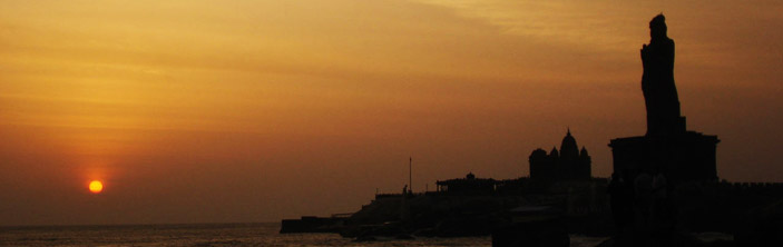
Though there are several places of tourist-interest in the town and district, Kanyakumari is especially popular in India for its spectacular and unique sunrise and sunset. The confluence of three ocean bodies – the Bay of Bengal, the Indian Ocean, and the Arabian Sea – makes the sunrise and sunset even more special. On balmy, full-moon evenings, (locally called Chitra Pournami) one can also see the moon-rise and sunset at the same time.
Tourist attractions
- Suchindram has the Sthanumalayan temple with a repository of art treasures belonging to several kingdoms. The temple is famous for its ninth-century inscriptions, musical columns, and 6-meter-tall statue of the vanara god Hanuman. The main deity in the form of a shivlinga represents Shiva, Vishnu, and Brahma, the trinity of the Hindu pantheon.
- Our Lady of Ransom Church situated in Kanyakumari,the place where the missionaries had preached the paravas and converted them to Christianity.The first church in the form of a thatched roof was built here in the early 15th century for venerating Santhosha Madha .The church at present stands 153 m tall and it was 100 years old.The new church was built in Gothic Architecture and it looks fabulous when seen with the seashore background, viewing from Our Lady of Ransom Arch near Church Road entrance.
- Vattakottai Fort (literally, "circular fort") is an 18th-century fort overlooking the sea, located six kilometres from Kanyakumari. The small historic fort also gives an enchanting view of the sea around and the hills on the other side.
- Lord Datta Temple is newly constructed near Vattakottai Fort. It is a second Datta Dham called "Anusaya Datta Dham". There are idols of Lord Dattatreya, Agastya Muni and Lord Ganesha.The sunrise and sunset is clearly seen from this temple.
- The Panchappathi, five primary sacred places of Ayyavazhi are all situated within a fifteen-kilometre radius of Kanyakumari. It also includes the Swamithope Pathi (headquarters of Ayyavazhi), a famous temple in Tamil Nadu, situated ten kilometres to the northwest. It is not a structurally massive temple, but is known for its non-idolatry system of worship.
- Nagercoil has the St. Francis Xavier's church at Kottar, where the missionary, St. Francis Xavier resided when he did his missionary work in the nearby areas. In Nagercoil, there is also the Nagaraja Temple, and shrines dedicated to Lord Shiva and Vishnu. The entrance to this temple is reminiscent of the Chinese architecture of a Buddhist Vihar.
- Padmanabhapuram Palace is a large 17th century palace of the Travancore kings, made almost entirely of wood – the only one of its kind in India.
- Udayagiri Fort, built by King Marthanda Varma, has a foundry for casting guns. It is also the tomb-site of the king's trusted European general Captain De Lennoy. Udayagiri Fort is now a bio-diversity park, administered by the Department of Forests, Kanyakumari Division.
- Mathur Hanging Trough, near Thiruvattar in the District, is an aqueduct that carries irrigation water through a canal between two hills. The canal itself goes above a small river. Built on very high pillars, is one of the biggest aqueducts, both in height and length, in Asia. The view from the middle of the aqueduct of the surrounding hills and vegetation, and the small river flowing down below, is breathtaking.
- 'Baywatch' (a water amusement-park), and wax museum (the only one of its kind in India) are the newest attractions, located within 2 km (1.2 mi) from Kanyakumari.
- Chitharal Jain Monuments (about 35 km (22 mi) near Marthandam), impressive rock shelters and idols dated 9–11th Century.
- Thirunandikkara temple (about 20 km (12 mi)), rock-cut cave temple of Pallava art can be traced back to seventh and eighth century AD.
- Thengapattinam Beach. This beach is located on the west coast near Painkulam village in Vilancode Taluk. It is a fine beach adorned with coconut groves. It is also a magnificent estuary where the river meets the sea. Riding in a catamaran (small boat) in the river can be a pleasant experience which can be arranged through local fishermen. It is 35 km (22 mi) from Nagercoil, 12 km (7 mi) from Kuzhithurai and 54 km (34 mi) from Kanyakumari.
- Olakaruvi waterfalls, about 20 km (12 mi) from Nagercoil is on the middle of a hill and requires an hour's trek by foot from the base of the hill (better to go in a group, as it is a forested area)
- Keeriparai – for nature-lovers and adventurers – pristine and beautiful, places like Keeriparai haven’t been publicized much by the Forest Department for various reasons – Keeriparai hills (30 km (19 mi) from Nagercoil) and the nearby Kalikesam are good picnicspots – one can enjoy water rushing through small mountain streams – with pebbles and ferns all around. There are also a few small waterfalls in this area – the popular one being Vattaparai Falls. Maramalai, which is further up in the hills of Keeriparai is famous for Wild elephants.
- Kodhayar (called Kodhayar Lower Camp) – is about 60 km (37 mi) and takes travellers through some exciting motorable hill roads with some thrilling "hair-pin bends" and U-turns; Kodhayar forests are famous for bisons. Access to some areas need prior permission from the Forest Department.
- Pechiparai Reservoir, about 30 km (19 mi) from the town, and also Perunchani and Chittar dams).
- Thiruparrapu Falls, is a waterfall near Thiruparrapu. There is an ancient temple near the falls, which is popular among the locals andKeralites.
- Muttom, a coastal village, is another popular place with tourists. The terrain in this village and its surroundings is hilly and from a height one can have an idyllic view of the place, with a Portuguese style church standing in the middle of the village. The beach-area is somewhat rocky. There is also a 100-year old lighthouse. The lighthouse, though near the sea, is situated on a land mass some 105 feet (32 m) above sea level. Another attractive feature of this area, is a ravine-like area with casurina trees near the seaside. This place with very popular with Tamil and Keralite film-makers, especially Tamil film director Bharathiraja.
- Sanguthurai Beach, about 8 km (5.0 mi) from Nagercoil is a palm-fringed and sandy beach. Sothavilai Beach is another good beach, about 7 km (4.3 mi) from the heart of town. Both beaches were hit by the Indian Ocean Tsunami, but authorities have taken steps to improve facilities again. There is a lagoon at Manakudy – 10 km (6 mi) from the town.
*accuracy of the facts and figures provided cannot be guaranteed